 SK
SK  DE
DE  EN
EN 
Canoeing on the Morava and Dyje
A peaceful river, floodplain scenery and a route from the Czech–Austrian–Slovak border region all the way to Devín.
The Dyje, known as the Thaya in Austria, rises in the Jihlava region and forms part of the border between the Czech Republic and Austria. It flows into the Morava near the meeting point of the Czech, Austrian and Slovak borders.
The Morava rises below Králický Sněžník and, from its confluence with the Dyje, forms the border between Slovakia and Austria. It flows into the Danube beneath the Devín cliffs and the ruins of Devín Castle.
Moravský Svätý Ján – Devín
A two-day journey down the Morava from Moravský Svätý Ján to its confluence with the Danube beneath Devín.
Břeclav – Devín
An extended weekend on the water that also includes the final section of the Dyje. The trip starts in Břeclav at U Splavu.
Equipment and transport from ATC Rudava
ATC Rudava has a canoe and paddling-equipment rental service and serves as a logistics base for paddlers on the Morava.
We can provide a canoe with the essential paddling equipment, transport both the canoes and your group, and give you an introductory briefing before departure. Canoeing on the Morava is not demanding and is suitable for beginners. Every participant receives a buoyancy aid and, on request, a waterproof barrel.
per canoe
Transport for people and canoes
If you cannot arrange your own transport, we can take you in our 8-seat minibus.
Loading the canoes: €10
Trailer for 4 canoes: €20
Sections of the Dyje and Morava
Times are approximate and depend on water levels, weather, the group’s pace and the length of breaks.
Břeclav – Moravský Svätý Ján
The Dyje section begins beyond Břeclav at U Splavu, near the railway bridge. The regulated channel and flood-protection embankments gradually give way to winding meanders through unspoilt floodplain countryside. After approximately 20 kilometres, the Dyje joins the Morava near the meeting point of the three national borders.
Moravský Svätý Ján – Gajary
The launch point is near the bridge connecting Moravský Svätý Ján with Hohenau in Austria. Approaching from the Slovak side, there is a gravel bank on the left, reached by lowering the canoes down a relatively steep slope. At an average pace of 6 km/h, the section takes just under four hours of active paddling.
Gajary – Záhorská Ves
A gently sloping launch point has been created beside the Morava at Gajary. At Záhorská Ves, canoes can land near the ferry ramp. Between river kilometres 34 and 35, you pass Suchohrad. Just under one kilometre downstream, a side channel has a concrete landing ramp on the right beside a Povodie Moravy jetty.
Záhorská Ves – Vysoká pri Morave
This section of just under 11 kilometres is one of the most popular routes. At Vysoká pri Morave, a large paved area beside the river serves as the standard place for preparing and launching canoes.
Vysoká pri Morave – Devínske jazero
Devínske jazero is a popular place to stop for refreshments or a barbecue. The location is a few hundred metres from the U starého bicykla refreshment stand.
Devínske jazero – Devín
The final section of the Morava leads to its confluence with the Danube beneath Devín Castle. The trip can end here, or experienced paddlers can continue along the Danube towards Karlova Ves.
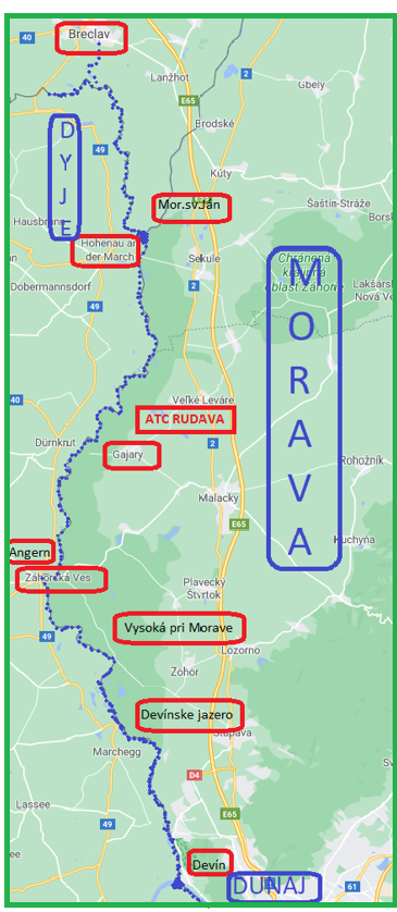
Route map
Click the map to view the Dyje and Morava rivers in full size.
Devín – Karloveské rameno
From Devín, experienced paddlers can continue along the Danube to the boathouses in Karlova Ves. The Danube is considerably faster and more demanding than the Morava. In the Devín Gate, paddlers must be prepared for a strong current, commercial river traffic, waves from high-speed vessels and stone groynes along the left bank.


